
Home › Forums › Questing › Does Anyone Know…? › Site Alignments – 11 mile measurements
This topic contains 0 replies, has 0 voices, and was last updated by imported_supernaturalist 19 years, 2 months ago.
-
AuthorPosts
-
April 3, 2007 at 3:26 pm #1679
This one is for Yuri initially, but anyone feel free to join in.
Yuri has mentioned an 11 mile distance between sites in the Somerset Paralellogram. How precise is this measurement, 11 miles on the nose, or within 1/4 mile, 1/2 mile? I would guess absolute precision would be quite hard to measure.
Also, are there any other sites of interest along the lines, between the 11 miles?
Anyone else tried looking for 11 mile distances along potential alignments?
Michael
April 24, 2007 at 12:41 am #2364Nicholas Mann, in his book ‘Glastonbury Tor’, says all four sides of the Somerset Parallelogram are 11 miles in length,
“… all lines conform to this measure from the points selected with an accuracy of about one percent or 200 yards… “
I have not checked it myself. I am quite content for there to be much margin of error in great landscape designs; I think its forgivable… if the entire ‘Michael Line’ is not a rigid straight line, I dont really care, its straight enough to not be ignored… and what is the width of a ‘line’? According to Paul Braodhurst, Hamish Miller dowsed the Michael line as being up to 50 yards in width in some places!!! it fluctuates. Braodhurst refers to the Michael Line as being a ‘corridor’ of sites rather than a ‘straight’ line
Do we really insist that medieval people and ancient people be accurate to the nearest millimeter with their designs?
April 24, 2007 at 12:59 pm #2366Thanks Yuri. I’m not insisting on anything, just curious about what would be considered to be acceptable tolerances if (and it’s a big if) there is something significant about the 11 mile distance.
But I appreciate your comments. Re the Michael line, I understand that Hamish Miller doused it as more of a meandering stream (or two intertwining streams) that follow an overall direction.
Michael
April 24, 2007 at 2:59 pm #2367It is frustrating. One desires to prove these things to acadamia so accuracy is desired. But then how perfect do the ancients need to be?
Yes, I am as relaxed as you, but I’ve been having these types of debates lately.
I am still astounded that the Bluestones of Stonehenge were transported 250 miles. lol. If it was just about ‘structure’ then any stone would do. The desire for these Bluestones must therefore imply a ‘value’ other than ‘structure’, be it mineral, acoustics, vibrations, religion or whatever?
Back to this 11 mile thing. It is, I believe, how John Michelle discovered the ‘Michael Line’, from Burrow Mump to the Tor is 11 miles, project onwards another 11 miles and you reach ‘Stoke St Michael’!
St. Michaels at Burrow Mump, 11 miles to St Michaels on the Tor, another 11 miles to Stoke St Michael. Three St. Michaels in a row, 11 miles apart (the central hub of the Michael Line!) I’ve done an article on this in the latest copy of the Temple booklet (issue 10)
http://www.thetemplebooklet.co.uk/The%2 … o%2010.htm
April 24, 2007 at 3:42 pm #2368As far as accuracy goes, I think 1% of 11 miles sounds pretty good without modern surveying technology. It works out as 11% of 1 mile, which gives a reasonable amount of leeway, as well as giving room for ‘the ancients’ to use the nearest useable feature.
I think the structure of ancient sites probably is important, but may not be the only consideration. Yes, odd why they needed to bring stones so far. Is the material itself important, or their place of origin?
April 24, 2007 at 11:51 pm #2373I would suggest that any fortuitous relationship between sacred sites (such as alignment of prominent hills), reinforces their status individually and as a group (by creating an overall context, or sacred landscape).
Equal spacing is even better.
Signifigant angles is good too, as are round numbers.
I don’t know if there’s anything particularly special about the 11 mile measure, per se, but it may be worthwhile converting it into other ancient units of measure to see if any significant numbers emerge (Surely JM would have tried this?).
In my own research, I have come across the repetition of a 9-mile distance within an example of pentagonal landscape geometry – 2 equal sides (legs) of an isoceles triangle, whose vertex angle is 72 degrees. 9 miles is 72 furlongs.
It’d be interesting to know what the angles of the Somerset Parallelogram are. Pretty sure that 88 degrees (that’s almost a right angle) won’t be among them (11 miles = 88 furlongs), although I dare say the Templecombe Head parallelogram won’t be far off that angle!
I don’t have my copy of The Temple 10 to hand, and unfortunately the graphic is missing on Yuri’s site (which unsurprisingly comes top in Google for ‘Somerset Parallelogram’!)…
April 25, 2007 at 9:42 am #2374Cripes! I just checked the Somerset Parallelogram diagram in Yuri’s Temple article, and the angles are 88 and 92.
Admittedly, the diagram is just a few lines and dots at a small scale, and not superimposed over the map, but it looks like a good fit. Anyone got a large scale map to hand?
April 25, 2007 at 10:44 am #2375OK, here’s the Somerset ‘Parallelogram’ on Google Maps
Doesn’t look quite so regular now, folks.
Yuri, please check I have the correct co-ordinates/locations.
April 25, 2007 at 12:15 pm #2376Just a quick apology.
When I put the parallelogram article into the Temple booklet. the editor asked me if I would take my webpage down. So that it was eclusive to the booklet; which I have done. That said, the article in the booklet is much more indepth than the webpage was. When the current issue is ‘old news’ I’ll re-build a proper webpage.
Perceval, really interesting responses there. Please note that the diagrams in the Temple booklet are not accurate, they are just ‘rough guides’ purely just to illustrate what I am talking about. The actual somerset parallelogram isn’t such a perfect ‘diamond’.
Your Google Map is really interesting but I can only see it as a flat rectangle, can it be made to fill the whole screen?
Nicholas Mann’s corners are,
1; the church on Burrow Mump
2; the summit of the Tor
3; Queen Anne’s Well, Cadbury
4; the northern tip of Hamdon Hill’s neolithic fort.I’ll scan his map for you.
April 25, 2007 at 12:36 pm #2377Hi Yuri,
I have quite a big monitor, so the view I saved may be too big for most. You may have to zoom out using the Google Map controls, or view full screen (F11).
Thanks for the info – I’ll recheck the locations later.
I have plans to plot the St Michael ‘line’ on Google Maps, and also Glastonbury Zodiac… and more besides!
April 25, 2007 at 12:44 pm #2378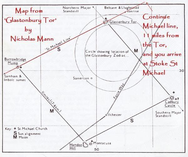
Each side of the Somerset Parallelogram is 11 miles in length. with a ‘St Michael church’ at each corner: on the mump, the tor, at north cadbury (just off Cadbury Castle) and a St Michaels Hill, just next to Hamdon.
Below Hamdon hill is the church of Stoke Sub Hamdon which has the three fire signs of the zodiac carved into its entrance. just a few miles from Cadbury is the site of the somerset Templar preceptory of Templecombe where the templecombe head is depicted framed by a zodiacal parallelogram. At the centre of the Glastonbury Zodiac (until 1901) lived the Hood family, apparently the origin of the surname ‘Hood’ means ‘head’!
The centre of the parallelogram is a crossroad called ‘ashen cross’, the coat of arms of the Hood family is a parallelogram crossed through by a St Andrews Cross. Next to ashen cross is Midney Farm (which seems to imply ‘middle’)
April 25, 2007 at 12:51 pm #2379Wow
Got the hang of that google map now. what an amazing gadget, brilliant!
;o)
April 25, 2007 at 1:26 pm #2380You can also add photos and video to saved overlays on Google Maps. Instructions here
You should also try Google Moon (zoom in to the max!).
-
AuthorPosts
You must be logged in to reply to this topic.