Home › Forums › Questing › Does Anyone Know…? › Hooe
This topic contains 0 replies, has 0 voices, and was last updated by imported_supernaturalist 20 years, 1 month ago.
-
AuthorPosts
-
May 4, 2006 at 3:22 pm #1650
If I may I’d like to start a topic on my home stomping ground in Hooe. Although not obviously interesting, being just a village that lies across the Plym/Cattewater from the city of Plymouth, there are a few things that are of potential interest which I’d like to share, and which others maybe able to shed some light on. I’ve grabbed a satellite image of the area and labelled a few places on it (excuse the lettered red blobs, courtesy of Google maps!).
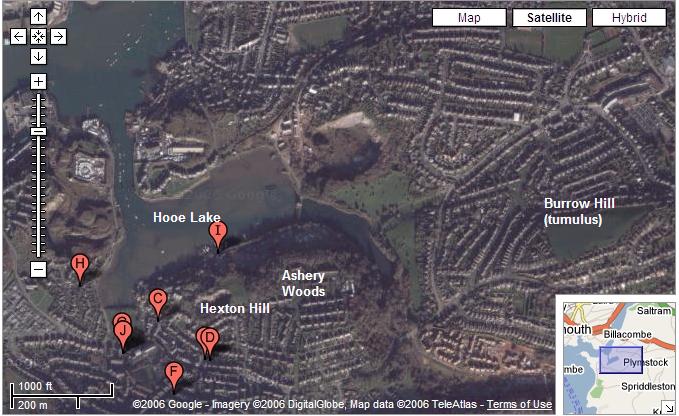
Most obvious, and perhaps most interesting, is Hooe Lake. The lake is tidal, and the ground on all sides rises up; in the past it would probably have looked much more dramatic than it does now, but a lot of quarrying has been carried out. The ‘leg’ on the east side is the freshwater lake of Radford Park, separated from Hooe Lake by a narrow bank. I’m not sure if it was excavated as a freshwater lake a few hundred years ago, or if it was once part of the main lake. The leg on the west side was part of the lake until the mid-60s, when it was filled in to create a village green.
According to what little I’ve managed to find on the archaeology of the site, the banks have been occupied since ancient times, evidence going back to the Bronze Age I think. A small Roman figure of Mercury was found by the lake according to one source, and is in a museum in Torquay or Torbay. However, somewhere else I read that that piece is probably fake, so I’m not worrying about that too much.
According to an information board in the woods there is a legend of a ‘white lady’ that haunts the lake. According to the legend it is the ghost of a lady from the now long-gone Radford House, who attempted to elope by boat across the lake but had a little accident and drowned. As the board says, there is no evidence for this story. I personally suspect that it has been made up to account for the sightings of a figure in white. Unfortunately I have so far been unable to discover anything else about this local legend, or anybody who claims to have seen her. I understand that white ladies are commonly associated with water sites, but that is about all I know about them. If anyone can shed any light I would be grateful. There is also supposed to be a ghostly monk where Radford House was (roughly south-east of the lake).
South of the foot on the western leg (where the red J is) used to be a manor house that would have been right next to the lake, and which down the centuries had generally been let as a farm. All that remains of it now is a decrepid barn. On the site of the manor used to be a small chapel dedicated to St Anne (supposedly the mother of the Virgin Mary). The name of the next-door village of Turnchapel (on the west of the picture) is thought to take its name from a corruption of St Anne’s Chapel. I was wondering if the St Anne association might be linked to the white lady? (As an aside, our parish church, atop the hill to the west of the lake, was originally to be dedicated to St Anne 150 years ago, but at the last minute the bishop objected because she isn’t in the Bible and so it was dedicated to St. John.)
As I watch the lake water go in and out each day I imagine a lunar connection, tides being dependent on the moon. There are often one or two swans to be seen on the lake, and I have also fancifully imagined these to be associated with the white lady (thought I’d mention my private delusion since reading the new Meonia article on AC’s website).
Immediately south of the lake is Hexton Hill. I find the name curious because I believe that the Saxon word hex has the broad meaning of ‘witch’ (derived in turn from the Greek hexe, meaning a female sorceror). The Saxon ton means a town. So does the hill refer to ‘witch-town’? I believe the name to be Saxon because the name of the village of Hooe is itself from the Saxon for a high place (and is also found in the famous Plymouth Hoe, where Francis Drake played bowls while waiting for the Spanish Armada).
In Ashery Woods, at the top of the hill, is a small cave entrace (it’s only a couple of feet wide and high if that – it has a bolted metal door across it to stop fools like me having a look and getting stuck), leading to a network of caves under the hill.
Finally, atop Burrow Hill is a tumulus (Plymouth’s only example I believe), which now has a war memorial slapped on top of it. The road on Burrow Hill is believed to be ancient, leading to Dartmoor one way and past Hooe to Mount Batten (a Bronze Age trading site on the headland) the other way. The hill is quite high, and there is a good view north to Dartmoor and west across the lake.
So that’s my little patch. It feels like there is some potentially interesting things there, but it seems very hard to find information. I’ve tried a few meditations, but I’ve not received anything. If anyone has any useful information or suggestions about any of this that would be great.
Michael
June 29, 2006 at 2:15 pm #2204I was sitting in the departure lounge of Plymouth City Airport about 2 weeks ago, waiting for our delayed flight to Gatwick, and my wife found an article on Drake’s Island in the May “Devon Life” that was available for passengers. Of interest was that going back to the 10th or 11th century, the island had a church dedicated to St. Michael on its summit and was known as “St. Michael’s Island”. Later in its history the church was rededicated to St. Nicholas and the island become “St. Nicholas’ Island”, and then in the 16th century it became known as Drake’s Island after the governorship of the island was offered to Sir Francis Drake.
I’ve found this verified here: [url:2hzl9mkj]http://www.plymouthdata.info/Drake’sIsland.htm[/url]
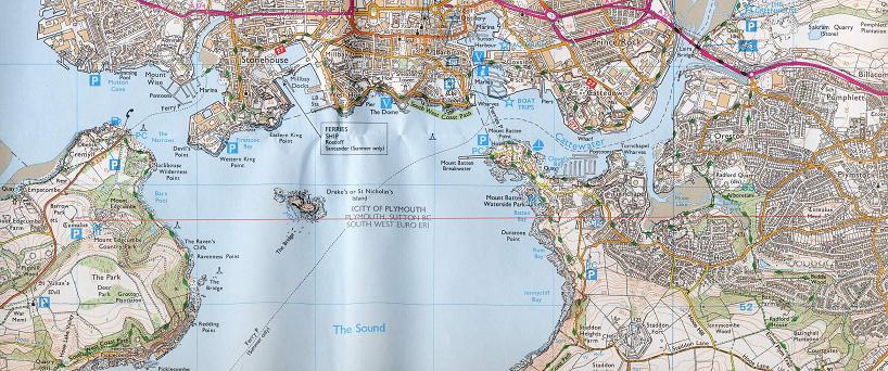
Quote:“There was a chapel on the Island that was originally dedicated to Saint Michael and it was as St Michael’s Island that it first appears in the records, when, in 1135, it was transferred from the Valletort family to the Priory at Plympton.”This is interesting, as it has similar characteristics to St. Michael’s Mount near Penzance as a small off-shore island with church of St. Michael. It is, however, quite far south of the Michael line, and quite far north of the Apollo line. Nevertheless, I did notice something of potential interest. Procurring an OS map, I noticed that on the Cornish side of the Plymouth Sound near Mount Edgecombe is a tumulus: a straight line between this and the Plymstock tumulus near Hooe hits the southern edge of St. Michael’s Island (as was), and is also a neat east-west line, which I guess would be an equinox alignment.
If this is a genuine alignment it cuts through Hooe Lake as well as the hill on which Stamford Fort was built in the 1860s (it passes right through the fort), on the slopes of which was found a late-iron age cemetery. I’ve marked it as a thin-red line on the map:
I’m not committed to the alignment being real, it could be a fluke. But it’s definitely interesting about the island. Thinking about Yuri’s recent Somerset post, does anyone know what angle I would need to plot a Beltane line from the island?
Michael (not a saint, not likely to become one)
June 29, 2006 at 3:50 pm #2205Your West/East line, is your Equinox horizontal
So, true north = 0 degrees
east = 90 degrees
south = 180 degrees
west = 270 degreesBeltaine is 63 degrees/ to Samhain at 243 degrees
so from St Michael’s Island, count true north as 0 degrees and move clockwise towards the north east, 63 degrees… thats your Beltaine alignment.
Try out the Somerset Parallelogram measurement of 11 miles; make the island the centre of your circle and draw an 11 mile radius around it to see if it lands anywhere of interest.
-
AuthorPosts
You must be logged in to reply to this topic.